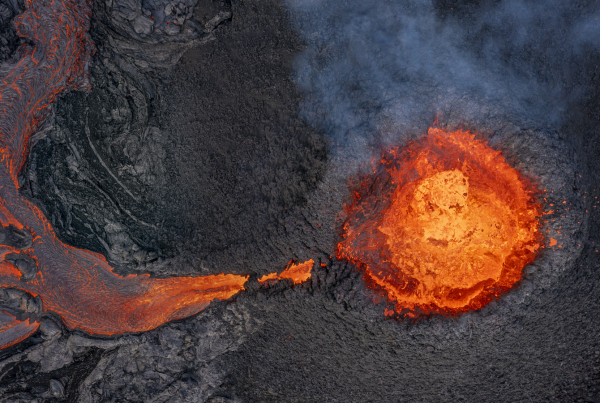
March 20, 2024 – Iceland is once again the stage for a powerful display of nature’s force with the onset of the March 16, 2024, fissure eruption on the Reykjanes Peninsula. This latest event, unfolding between Hagafell and Stóra Skógfell, close to both the Blue Lagoon and the town of Grindavik, continues the trend of volcanic activity that has characterized the area, marking it as the seventh eruption since 2021 and the fourth near Grindavík in just four months.

The March eruption at the Reykjanes Peninsula. Picture: Almannavarnir
A Closer Look at the Current Eruption
The March 2024 eruption is more than just a spectacle; the continuous flow of magma beneath the Svartsengi area, leading to this eruption, underscores the ever-changing nature of the Icelandic landscape. Despite the frequent eruptions, the Icelandic Meteorological Office and local authorities have adeptly managed these natural events, ensuring the safety of both residents and visitors.
Education and Observation: Key to Understanding
The repetitive nature of these eruptions near Grindavík offers unparalleled opportunities for scientific study and public education. Facilities like the LAVA Centre play a crucial role in this educational endeavour, providing visitors with interactive exhibits and expert explanations about the science of volcanoes, the intricacies of Iceland’s geology, and the impact of volcanic activity on the environment and society.

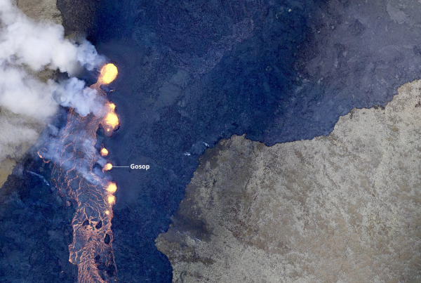
The eruption seen from above the evacuated town of Grindavik. Picture: Almannavarnir/Björn Oddsson
Safety and Travel: Exploring Iceland with Confidence
While the volcanic activity might seem daunting, Iceland’s robust monitoring and emergency preparedness systems mean that the island remains a safe destination for travellers. The ongoing eruption is closely monitored, with any potential hazards being communicated clearly and promptly. The vast majority of Iceland, including its most famous tourist attractions, remains unaffected by the current geological unrest.
The LAVA Centre: Your Gateway to Geological Wonders
For those looking to dive deeper into the story of Iceland’s volcanic activity, the LAVA Centre offers an immersive educational experience. Here, visitors can explore the forces that shape the Earth, understand the science behind eruptions, and appreciate the beauty and power of nature in a safe and engaging environment.
Conclusion: Embracing the Power of Nature, Safely
Iceland’s March 2024 eruption offers both challenges and opportunities for learning and exploration. With the country’s commitment to safety, education, and the sharing of knowledge, visitors can experience the awe of volcanic activity while being assured of their safety. Iceland continues to welcome the curious, the adventurous, and the scholarly to witness the grandeur of nature’s artistry, underscored by a deep respect for the forces that shape our world.
Discover the reasons Iceland remains a safe destination despite volcanic activity by exploring insights from Dr. Matthew Roberts, Managing Director at the Icelandic Met Office, in the following informative Q&A session by Visit Iceland:
Q&A about the volcanic activity on the Reykjanes Peninsula
-
Is it safe to travel to Iceland during the current volcanic eruption?
Yes, it is safe to travel to Iceland. The country is well-equipped to monitor volcanic activity and provide timely updates and safety advice. The affected area is isolated and does not impact the majority of the country, including popular tourist destinations.
-
How has the eruption affected air traffic to and from Iceland?
As of now, there has been no disruption to air traffic to and from Iceland. Icelandic authorities are experienced in managing volcanic activity to minimize its impact on air travel, and all airports remain operational.
-
Can I still visit the Blue Lagoon, or has the eruption impacted it?
The Blue Lagoon, located in the Reykjanes Peninsula, has been affected by the current eruption. It is currently closed (20 March 2024) but continues to welcome visitors under strict protocols when no eruption is ongoing. It’s always a good idea to check the latest updates from the attraction’s official website or local authorities before your visit. The Blue Lagoon is one of the wonders of the world and one of the biggest attractions in Iceland. We still recommend visiting but also point out many other lagoons in Iceland.
SkyLagoon
Hvammsvík
Secret Lagoon
Fontana
Krauma
Húsafell Canyon Baths
-
What safety precautions should visitors take when traveling to areas near the eruption site?
Visitors should follow guidance from the Icelandic Meteorological Office and local authorities, including staying out of restricted areas, being aware of gas emissions, and following any evacuation orders. It’s also advisable to have a travel plan that includes safety measures and to stay informed about the latest developments. This is not a tourist attraction, it is still considered dangerous and visitors are not allowed to visit the site. We recommend reading Visit Iceland, Safe Travel Iceland and the Icelandic Met Office.
-
How is the current eruption being monitored for public safety?
The Icelandic Meteorological Office continuously monitors volcanic activity using a range of tools, including seismic sensors, GPS measurements, satellite imagery, and on-site observations. This data helps assess the eruption’s progress and potential impact on public safety.
-
Are tours and outdoor activities in the vicinity of the eruption site still operational?
Tours and activities near the eruption site may be temporarily suspended or rerouted for safety reasons. Tour operators are closely following official guidance and will ensure visitors’ safety is the top priority. Check with tour providers for the most current information.
-
How does the LAVA Centre provide insights into the current eruption?
The LAVA Centre offers interactive exhibits and educational resources that explain the science behind volcanic activity, including the current eruption. Visitors can learn about the geological forces at work and the history of volcanic activity in Iceland. Our hosts provide deep knowledge and local sentiments on the eruptions.
-
What measures are in place to alert visitors and residents of any sudden changes in volcanic activity?
Iceland has a robust alert system that includes emergency notifications through mobile apps, social media, and local media outlets, similar to Amber alerts in the US. These systems ensure that residents and visitors receive timely information about any changes in volcanic activity or safety instructions. As soon as you enter the vicinity of the area you should receive a SMS. This also happens when you enter in the vicinity of Hekla Volcano close to LAVA Centre.
-
In light of the recent eruptions, how can visitors stay informed about the situation?
Visitors can stay informed by monitoring updates from the Icelandic Meteorological Office, Safe Travel Iceland, and the Department of Civil Protection and Emergency Management. These sources provide reliable and up-to-date information on volcanic activity and travel safety.
-
What makes the Reykjanes Peninsula’s volcanic activity unique compared to other regions in Iceland?
The Reykjanes Peninsula is characterized by a tectonic plate boundary that runs through Iceland. This area’s volcanic activity is closely related to the movement of the Eurasian and North American tectonic plates, making its geological features and eruptions unique in terms of their frequency, type, and impact on the landscape. What is also unique with the area is how young it is and how it has not yet formed established volcanoes within the volcanic zones.
-
How large is the affected area compared to the size of Manhattan and other international landmarks?

Hazard map for volcanic unrest. Map: Icelandic Met Office
The affected area by the recent volcanic eruption in Iceland is approximately 60 square kilometres. This size is slightly larger than the entirety of Manhattan, New York, which spans about 59.13 square kilometres. To give you a perspective from the United Kingdom, the area is larger than the city of Oxford, which covers about 45.59 square kilometres, providing a sense of the eruption’s geographical scale. For an international comparison, the affected area is more than half the size of the central part of Paris, enclosed by the Périphérique ring road, which is about 105 square kilometres. This comparison illustrates the significant scale of the volcanic activity and the extensive nature of the landscape impacted by the eruption.